| Maps
Things have been a little busy lately. It's those pesky deadlines again. That and pretty pictures. Mark Woods, at wood s lot, mentioned this site. This is, without a doubt, just about the most amazing thing I have seen on the web.
David Rumsey Collection
The David Rumsey Historical Map Collection focuses on rare 18th and 19th century North and South America cartographic history materials. Historic maps of the World, Europe, Asia and Africa are also represented. The collection categories include old and antique atlas, globe, school geography, maritime chart, state, county, city, pocket, wall, children and manuscript maps. Genealogy and family history can be studied on the maps. The online collection is an expanding cross section of digital images designed to highlight the depth of the collection. The digital images and descriptive data are © Cartography Associates. Read more about the collection. New! Read Article about the collection.
New! 1012 new maps added December 15, 2001 to the David Rumsey Collection. Total maps online is now 6480. Read More
[read more]
The first amazing thing is that this dude obviously has a lot of money and likes to collect really cool maps.
The second amazing thing is that he wants everyone to see the collection and to be able to use it—for no charge. Emphasis on *use*.
You view these maps through a Java browser. Select the map and then you can zoom in to incredible levels of detail.
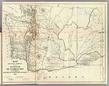
This is an 1866 map of Washington.
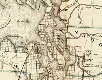
Now we are zoomed in to the area north of Seattle. That's Whidbey Island, where I live.
This is zoomed in all the way.
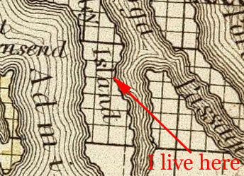
These maps really are works of art.
But wait! There's more! The have a new and improved Java browser that you can download that makes it easier to move around the maps and it lets you download high quality images. I downloaded the above map at the highest level of resolution. It was an almost 23mb jpeg file. Opening it in Photoshop expanded it to a 215mb file. *BIG!* You can see the texture of the paper. I just enlarged it to 100%, went full screen, and used the hand tool to wander around the map. Beautiful! The image expanded, at 72 pixels/inch, to 135 inches by 106 inches, or 9,779 pixels by 7,696 pixels. Lotsa pixels. It helps to have DSL and 512mb of RAM.
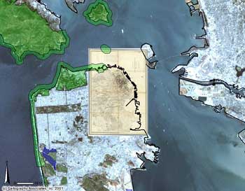
But Wait! There's More! They are just starting to take this to the next level. They are combining these old maps with satelite imagery.
GIS and Historical Maps from the David Rumsey Collection
New Feature! Introducing a special GIS (Geographic Information System) Browser that allows integration and interaction of historical maps with current geospatial data and other historical maps. Examination of the maps in GIS reveals changes in the history of the areas shown on the maps.
Eleven historical maps of the San Francisco Bay area from 1851 to 1926 from the David Rumsey Collection are now available for viewing in the GIS Browser. Additional historic maps of U.S. cities will be added in the near future, including New York, Boston, Washington, Los Angeles, and others.
The current geospatial data that can be overlaid and compared to the historical maps includes roads, lakes, parks, state boundaries, digital orthophotos (aerial photography), topographic mapsheets, digital elevation models and satellite imagery.
[read more]
I could go on but I have some maps to look at. |