| maps
Amsterdam Realtime
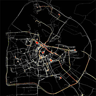
During two months (3 Oct to 1 Dec 2002) all of Amsterdam's citizens are invited to be equipped with a tracer-unit. This is a portable device developed by Waag Society which is equipped with GPS: Global Positioning System. Using satellite data the tracer calculates its geographical position. Therse tracers' data are sent in realtime to a central point. By visualizing this data against a black background traces, lines, appear. From these lines a (partial) map of Amsterdam constructs itself. This map does not register streets or blocks of houses, but consists of the sheer movements of real pepole.
[more]
thanks to boingboing |