| maps
Map of the World
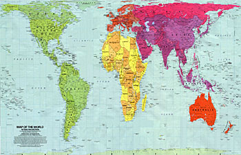
Arno Peters Projection
Scientific accuracy-
The Peters map precisely represents the area on the globe allowing for an accurate study of size and accurate longitudinal coordinates to be calculated.
Social Equality-
By portraying the size relationships of the north and south, the Peters map gives the real size relations of all countries on the map.
Thought Provocation-
By showing a representation of the world that we are not accustomed to, the Peters map gives us pause to think about the representation of the world and the ways in which we relate to it. It also points out the general lack of knowledge about geography most people in the world have.
[more]
thanks to Spitting Image
|